![](/images/other/stat-length.png)
![Trail Mountain bike Le Bonhomme - Les Bagenelles - Le Bonhomme - Photo](https://media.geolcdn.com/t/1900/400/ext.pjpeg?maxdim=2&url=https%3A%2F%2Fservices.sitytrail.com%2FGeolivesWS%2FDownloadMedia.ashx%3FTrailID%3D172865%26Media%3D14317_3.jpg)
Les Bagenelles - Le Bonhomme
tracegps
User
![Length](/images/other/stat-length.png)
Length
14.2 km
![Max alt](https://static1.geolcdn.com/siteimages/upload/files/1508320355ic_sort_altitude_max_24dp.png)
Max alt
987 m
![Uphill gradient](https://static1.geolcdn.com/siteimages/upload/files/1508320355ic_sort_den_pos_24dp.png)
Uphill gradient
413 m
![Km-Effort](/images/other/stat-length.png)
Km-Effort
19.7 km
![Min alt](https://static1.geolcdn.com/siteimages/upload/files/1508320355ic_sort_altitude_min_24dp.png)
Min alt
661 m
![Downhill gradient](https://static1.geolcdn.com/siteimages/upload/files/1508320355ic_sort_den_neg_24dp.png)
Downhill gradient
415 m
![Boucle](https://static1.geolcdn.com/siteimages/upload/files/16400158638029165_repeat_loop_refresh_sync_direction_icon.png)
Boucle
Yes
Creation date :
2014-12-10 00:00:00.0
Updated on :
2014-12-10 00:00:00.0
![Mountain bike](https://static1.geolcdn.com/sitytour/trail-icons/202.png)
1h45
Difficulty : Medium
![Scan this QR Code to open this trail in the SityTrail application](https://capi.geolives.com/qq0zvz2zws4bq2lad0pu/sitytour/trails/172865/qr.png?size=200)
FREE GPS app for hiking
About
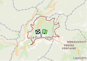
Trail Mountain bike of 14.2 km to be discovered at Grand Est, Haut-Rhin, Le Bonhomme. This trail is proposed by tracegps.
Description
Au départ du village du Bonhomme, 14 kilomètres de balades en direction du Col des Bagenelles. Vue à ne pas manquer au kilomètre 11.
Positioning
Country:
France
Region :
Grand Est
Department/Province :
Haut-Rhin
Municipality :
Le Bonhomme
Location:
Unknown
Start:(Dec)
Start:(UTM)
359758 ; 5337220 (32U) N.
Comments
Trails nearby
![Trail Walking Le Bonhomme - Tête des faux . - Photo](https://media.geolcdn.com/t/375/260/84fec98d-7f8b-4bf8-a434-52c0363ad440.jpg&format=jpg&maxdim=2)
![Walking Walking](https://static1.geolcdn.com/sitytour/trail-icons/101.png)
Tête des faux .
Walking
Medium
(1)
Le Bonhomme,
Grand Est,
Haut-Rhin,
France
![](/images/other/stat-length.png)
11.9 km | 16.6 km-effort
3h 46min
![](https://static1.geolcdn.com/siteimages/upload/files/16400158638029165_repeat_loop_refresh_sync_direction_icon.png)
Yes
![Trail Walking Lapoutroie - 2012-06-16 Marche aux Alisiers Orbey - Photo](https://media.geolcdn.com/t/375/260/ext.jpg?maxdim=2&url=https%3A%2F%2Fstatic1.geolcdn.com%2Fsiteimages%2Fupload%2Ffiles%2F1553511878bg_sport_marche.png)
![Walking Walking](https://static1.geolcdn.com/sitytour/trail-icons/101.png)
2012-06-16 Marche aux Alisiers Orbey
Walking
Easy
(2)
Lapoutroie,
Grand Est,
Haut-Rhin,
France
![](/images/other/stat-length.png)
11.1 km | 16.6 km-effort
2h 49min
![](https://static1.geolcdn.com/siteimages/upload/files/16400158638029165_repeat_loop_refresh_sync_direction_icon.png)
Yes
![Trail Mountain bike Orbey - Lac Blanc - Têtes des Faux - Photo](https://media.geolcdn.com/t/375/260/ext.jpg?maxdim=2&url=https%3A%2F%2Fservices.sitytrail.com%2FGeolivesWS%2FDownloadMedia.ashx%3FTrailID%3D101197%26Media%3D684_1.jpg)
![Mountain bike Mountain bike](https://static1.geolcdn.com/sitytour/trail-icons/202.png)
Lac Blanc - Têtes des Faux
Mountain bike
Medium
(1)
Orbey,
Grand Est,
Haut-Rhin,
France
![](/images/other/stat-length.png)
15.3 km | 21 km-effort
1h 0min
![](https://static1.geolcdn.com/siteimages/upload/files/16400158638029165_repeat_loop_refresh_sync_direction_icon.png)
Yes
![Trail Walking Le Bonhomme - Le Bonhomme - Circuit du village - Photo](https://media.geolcdn.com/t/375/260/ext.jpg?maxdim=2&url=https%3A%2F%2Fstatic1.geolcdn.com%2Fsiteimages%2Fupload%2Ffiles%2F1553511878bg_sport_marche.png)
![Walking Walking](https://static1.geolcdn.com/sitytour/trail-icons/101.png)
Le Bonhomme - Circuit du village
Walking
Easy
(1)
Le Bonhomme,
Grand Est,
Haut-Rhin,
France
![](/images/other/stat-length.png)
3 km | 5.3 km-effort
1h 30min
![](https://static1.geolcdn.com/siteimages/upload/files/16400158638029165_repeat_loop_refresh_sync_direction_icon.png)
Yes
![Trail Walking Sainte-Marie-aux-Mines - 2021-02-14 Marche Bagenelles Brezouard Fuste de Etoile - Photo](https://media.geolcdn.com/t/375/260/79d211e6-ae5a-4d3f-8163-d2103469db38.jpg&format=jpg&maxdim=2)
![Walking Walking](https://static1.geolcdn.com/sitytour/trail-icons/101.png)
2021-02-14 Marche Bagenelles Brezouard Fuste de Etoile
Walking
Very difficult
Sainte-Marie-aux-Mines,
Grand Est,
Haut-Rhin,
France
![](/images/other/stat-length.png)
17.1 km | 27 km-effort
6h 6min
![](https://static1.geolcdn.com/siteimages/upload/files/16400158638029165_repeat_loop_refresh_sync_direction_icon.png)
Yes
![Trail Walking Lapoutroie - 2020-07-19 Marche Étang du Devin Col Calvaire Tête des Faux - Photo](https://media.geolcdn.com/t/375/260/615f03a1-e6aa-4706-9550-1df8400dcef8.jpg&format=jpg&maxdim=2)
![Walking Walking](https://static1.geolcdn.com/sitytour/trail-icons/101.png)
2020-07-19 Marche Étang du Devin Col Calvaire Tête des Faux
Walking
Very easy
Lapoutroie,
Grand Est,
Haut-Rhin,
France
![](/images/other/stat-length.png)
14.2 km | 22 km-effort
3h 27min
![](https://static1.geolcdn.com/siteimages/upload/files/16400158638029165_repeat_loop_refresh_sync_direction_icon.png)
Yes
![Trail Walking Orbey - Vallée des 5 lacs - Photo](https://media.geolcdn.com/t/375/260/96031f65-b958-4b6d-af19-7cecb860729d.jpg&format=jpg&maxdim=2)
![Walking Walking](https://static1.geolcdn.com/sitytour/trail-icons/101.png)
Vallée des 5 lacs
Walking
Difficult
Orbey,
Grand Est,
Haut-Rhin,
France
![](/images/other/stat-length.png)
28 km | 48 km-effort
7h 21min
![](https://static1.geolcdn.com/siteimages/upload/files/16400158638029165_repeat_loop_refresh_sync_direction_icon.png)
Yes
![Trail Walking Orbey - Col du Calvaire ➡️ Lac Blanc - Photo](https://media.geolcdn.com/t/375/260/d45f3e65-0b13-4169-803a-9a82fdb05a2b.jpg&format=jpg&maxdim=2)
![Walking Walking](https://static1.geolcdn.com/sitytour/trail-icons/101.png)
Col du Calvaire ➡️ Lac Blanc
Walking
Medium
Orbey,
Grand Est,
Haut-Rhin,
France
![](/images/other/stat-length.png)
8.6 km | 12.8 km-effort
3h 9min
![](https://static1.geolcdn.com/siteimages/upload/files/16400158638029165_repeat_loop_refresh_sync_direction_icon.png)
Yes
![Trail Electric bike Le Bonhomme - Lac blanc col de la schlucht Six fours lac noir - Photo](https://media.geolcdn.com/t/375/260/5114f748-f66d-451b-a007-e5776d8e4296.jpg&format=jpg&maxdim=2)
![Electric bike Electric bike](https://static1.geolcdn.com/sitytour/trail-icons/205.png)
Lac blanc col de la schlucht Six fours lac noir
Electric bike
Medium
Le Bonhomme,
Grand Est,
Haut-Rhin,
France
![](/images/other/stat-length.png)
39 km | 49 km-effort
2h 57min
![](https://static1.geolcdn.com/siteimages/upload/files/16400158638029165_repeat_loop_refresh_sync_direction_icon.png)
Yes